
Where to stay near Chapada Diamantina National Park: the 3 areas to know in 2026
Photo : ophelie
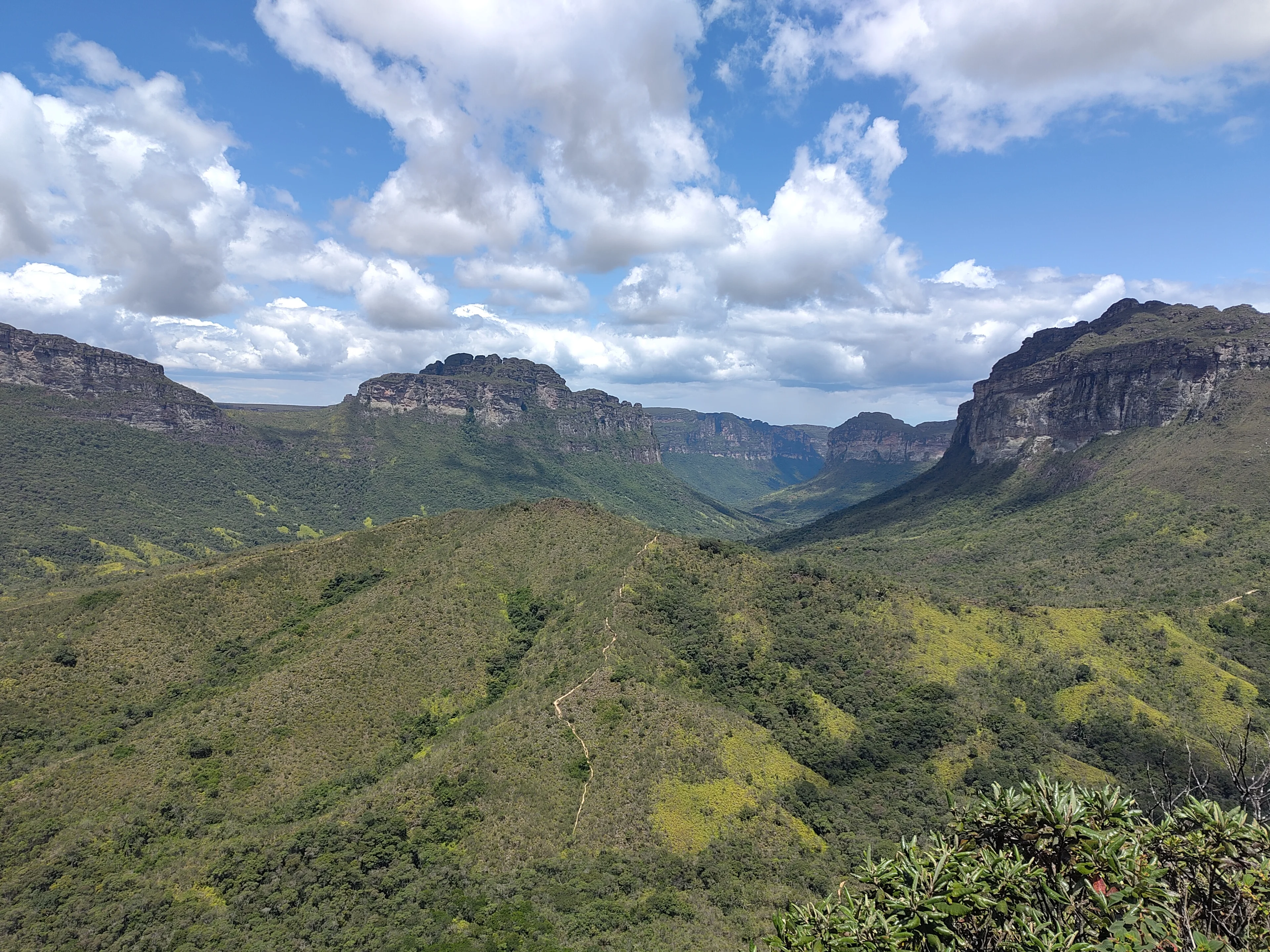
This park has no gate, no ticket desk and no visitor centre: the institute that runs it says so itself, and that is why there is nothing to pay to get in. What it has is 38 trail entrances spread over six municipalities, for 1,521 square kilometres. The question is therefore not how far from the park to sleep, but which municipality to enter through: the answer changes the trails of the whole week.
One figure sums up the geography. The point the listing carries lies 8.3 kilometres from Lençóis as the crow flies, and 72.5 kilometres by road: no route crosses the massif, you go around it. Three poles share the nights, separated by an hour and a half to two hours at the wheel: Lençóis in the north-east, the Vale do Capão in the north-west, Igatu and Mucugê in the south.
Compare hotel prices near Chapada Diamantina National Park
In a hurry? Find the best accommodation deals in 3 clicks.
Compare live deals from Booking, Expedia, Agoda and other partners.
The two ways to stay near Chapada Diamantina National Park
Nothing is paid at the entrance and nothing is signposted: what gets decided is the municipality you enter through, and therefore the trails of the week.
| What changes | In Lençóis, in the north-east | In the Vale do Capão, in the north-west |
|---|---|---|
| The Fumaça trail | 73.9 kilometres to reach its start | It leaves from this valley |
| The Morro do Pai Inácio | 26.2 kilometres, 26 minutes | 47.3 kilometres, 58 minutes |
| The agencies and the tables | On the corner of every pousada | A valley, not a town |
| The Vale do Pati crossings | The agencies sell them here | They begin here |
| The scores from our readings | The town's own guide details them | 9.6 and 9.1 |
| A swim on foot | The Ribeirão do Meio from the town | The waterfalls of the valley |
| The south of the park | Igatu 108.1 kilometres away | Further still |
| For whom | Anyone booking their days on arrival | Anyone walking several days in a row |
How long to the entrance, area by area?
These distances are ROAD distances, counted from Lençóis, the municipality most stays start from; the note on each line gives the Morro do Pai Inácio, the viewpoint everyone wants to see. The point of the listing itself lies in the heart of the massif, 1.3 kilometres from the Cachoeira da Fumaça as the crow flies.
| From | Time | How |
|---|---|---|
| Lençóis, the town of the agencies | on site | on foot in the town The Morro do Pai Inácio is 26.2 kilometres and twenty-six minutes away, by Palmeiras. |
| The Vale do Capão, where the treks start | 73.9 km, 85 min | by Palmeiras The Morro do Pai Inácio is 47.3 kilometres and fifty-eight minutes away. |
| Igatu and the south, by Mucugê | 108.1 km, 106 min | by the south Mucugê is 20.9 kilometres away, the Morro do Pai Inácio 97.8 from Mucugê. |
At a glance: our picks by traveller type
Pick the profile that fits you and go straight to the recommended area.
Map of the areas near Chapada Diamantina National Park
See how the areas sit relative to one another before choosing your base. Click a name to jump to its description.
Lençóis, the town of the agencies 26.2 kilometres from the Morro do Pai Inácio, 10,774 inhabitants
Anyone who wants to book their days on arrival
Ten thousand seven hundred and seventy-four inhabitants, and the only municipality in the park where the agencies, the tables and the transport fit into the same few streets: this is the base of most stays. The Morro do Pai Inácio is 26.2 kilometres and twenty-six minutes away by the Palmeiras road, and you walk to the Ribeirão do Meio without getting back in the car. Its pousadas have their own guide with us, street by street: the card below leads there.
Treks, waterfalls, and caves are all on the agenda, not to mention the very warm welcome from the people of Bahia
Other things to do in this area


 Stay in the city
Where to stay in Lençóis
Lençóis has its own guide: neighbourhoods, prices, our recommended hotels.
Pros
- The agencies, the tables and the buses in the same streets
- A swim you reach without a car
- Twenty-six minutes from the Morro do Pai Inácio
Cons
- The Vale do Capão 73.9 kilometres away by road
- The south of the park more than a hundred kilometres off
The Vale do Capão, where the treks start 73.9 kilometres from Lençóis, municipality of Palmeiras
Anyone coming to walk for several days
It is from Campos, in this valley of the Palmeiras municipality, that the trail to the Cachoeira da Fumaça leaves: about 5 kilometres and two hours of walking, one of them a steep climb, for a waterfall of 380 to 420 metres that is looked at rather than swum in. It is also from here that the crossings of the Vale do Pati begin, which last several days and are slept in the homes of the inhabitants. Our two addresses hold 9.6 and 9.1, the highest figures in this guide.
Where to stay in this area
Pousada Bela Vista do Capão Mid-range
9.6 across more than 140 reviews, the highest figure on these pages: in the valley the Fumaça trail leaves from.
Pousada Aconchego Mid-range
9.1 across more than 60 reviews, location and staff 9.5: a house in the Capão, within reach of the trek departures.
Pros
- The Fumaça trail leaves from this valley
- The Pati crossings begin here
- 9.6 and 9.1, the two highest figures on these pages
Cons
- Eighty-five minutes of road from Lençóis
- Fifty-eight minutes to the Morro do Pai Inácio
Igatu and the south, by Mucugê 108.1 kilometres from Lençóis, 20.9 from Mucugê
Anyone after the south of the massif and its stone ruins
108.1 kilometres and 106 minutes separate Igatu from Lençóis: this is another Chapada, the one of dry stone houses left by the diamond prospectors, and the one of the southern trails. Mucugê, 12,137 inhabitants, is twenty-one minutes away, and the Morro do Pai Inácio 114 minutes. Our address here holds 9.5 across more than 250 reviews, the largest volume in this guide.
Where to stay in this area
Pousada Flor de Açucena Mid-range
9.5 across more than 250 reviews, the highest volume on these pages: in the stone village, twenty-one minutes from Mucugê.
Pros
- The dry stone village of the diamond prospectors
- Twenty-one minutes from Mucugê and its trails
- 9.5 across more than 250 reviews
Cons
- 106 minutes of road from Lençóis
- The Morro do Pai Inácio 114 minutes away
Our tips for booking the right place
- No ticket, no gate, and 38 trail entrances: The institute that runs the park writes it plainly: there is no reception structure inside, no booth and no visitor centre, and therefore no entry fee. What the park has is 38 trail entrances spread over six municipalities, Andaraí, Ibicoara, Itaetê, Lençóis, Mucugê and Palmeiras, for 152,141 hectares protected since a decree of September 1985, that is 1,521 square kilometres. The administrative headquarters are in Palmeiras. The practical consequence: nobody will tell you where to start when you arrive, and the choice of municipality is the only filter you have left.
- The trails are not signposted, and the telephone does not work: Two details from the institute are worth more than a general warning. First, no guide is formally compulsory, but it recommends hiring a visitor conductor, because the trails are not signposted. Second, there is no mobile phone signal in the park, and it recommends telling your family what you plan to do before setting off. That is what gives full weight to the word « car » in our member's review: without a vehicle and without an agency, access to the 38 entrances shrinks to whatever the buses serve.
- The Cachoeira da Fumaça is looked at, not swum in: It measures 380 to 420 metres, and that is why the Vale do Capão is in this guide: the trail leaves from Campos, in that valley of the Palmeiras municipality, and runs about 5 kilometres for two hours of walking, one of them a steep climb. The institute specifies that the waterfall is to be contemplated rather than swum in, which surprises anyone who has seen the photographs taken from the lip. From Lençóis, reaching that trailhead takes 73.9 kilometres and eighty-five minutes of driving: the kind of trip you do not make twice in one day.
- The Vale do Pati is slept in people's homes, not under canvas: The emblematic crossing of the massif lasts several days, and the institute gives its particularity: the lodging is in the houses of the inhabitants, not in free bivouac. The views of the Morro do Castelo are its most quoted passage. That changes two things for anyone booking: the room for the first and the last evening is taken in the Vale do Capão or in Lençóis, and the rest is settled with the families of the Pati, through a conductor. Our member sums up the time it takes: « if you have a spare week and a car, do not hesitate to spend some time in this region ».
- 8.3 kilometres as the crow flies, 72.5 by road: The point carried by this park's listing lies in the heart of the massif, 1.3 kilometres from the Cachoeira da Fumaça and 8.3 kilometres from Lençóis in a straight line. By road, those 8.3 kilometres become 72.5 kilometres and eighty-five minutes, because no driveable route crosses the Chapada: you go around it. That is why the three areas on this page are so far from each other, and why a stay that wants the Fumaça, the Pai Inácio and Igatu all at once spends more time in the car than on foot.
- Counting on a visitor centre when you arrive: there is none in the park.
- Planning the Fumaça from Lençóis without counting the road: 73.9 kilometres and eighty-five minutes to the trailhead.
- Setting out on a trail counting on your phone: there is no signal in the park.
- Booking a night in Igatu to see the Morro do Pai Inácio: 114 minutes separate the two.
FAQ: where to stay near Chapada Diamantina National Park
Do you have to pay to enter the park?
Which municipality should we sleep in?
Are our Lençóis addresses on this page?
Do you need a guide to walk?
How long should we stay?
Can you swim at the foot of the Cachoeira da Fumaça?
Hotels available near Chapada Diamantina National Park, on the map
Tonight's availability and prices, hotel by hotel, at the distance you choose.
Compare live deals from Booking, Expedia, Agoda and other partners.
 Keep exploring
Everything about Chapada Diamantina National Park: reviews, photos, practical info
Comments (0)
No comments yet. Be the first!